• The Columbia Gorge creates all kinds of uniquely local weather by virtue of funneling mild, moist Pacific air into the cold, dry interior east of the Cascades – or vice-versa, depending on the wind direction. In winter, this can create the rare instance of sunny weather on the normally rainy west side of the mountains and dank, freezing fog on the normally dry arid east side. For folks living in the East Gorge, this isn’t welcome weather. It’s an uncomfortable mix of high humidity and temperatures hovering around freezing that can sometimes linger for weeks.

    One upside? When this cold, gray condition persists for more than a few days, it can create a magical winter landscape in the forests along the east slopes of the mountains, especially at the margins of the sea of fog that fills the Columbia basin. Often, warmer sunny skies are just a few hundred feet above the foggy forests, just out of reach. This scene on the slopes of Lookout Mountain is along the eastern fringe of the Ponderosa forests, where the pine forests give way to Oregon white oak savannah in the rain shadow of the Cascades.

    Unlike a silver thaw where freezing rain covers trees in a glaze of clear ice, these Ponderosa are flocked with delicate ice crystals that continue to grow as fog conditions persist – sometimes up to 2 inches in length. The stillness of the fog is a secret ingredient, however, as even the slightest wind will bring them down in a blizzard of fine crystals.

    ___________

    Image Description: A group of tall Ponderosa pine rise up from snow-covered ground into a freezing, foggy sky. Their limbs are flocked with a thick coating of ice crystals formed over several days in the fog. Their distinctive reddish-barked trunks stand in warm contrast to the cool blues and winter white of this scene.

    Photo © WyEast Images (2026)

  • The winter colors along this section of the lower Deschutes River (just below Rattlesnake Canyon) can seem like a return to fall at first glance. However, the ruddy hues that light up the river this time of year aren’t leaves, they’re catkins emerging from the White alder groves that line the shore. 

    Though they favor life along the water here, White alders are a unique, drought-tolerant species among the alders, mostly growing east of the Cascades and on the floor of the Willamette Valley, where summers are hot and dry. Their Red alder cousins only grow in Oregon’s wettest forests, along the coast, in the Coast Range and on the west slope of Cascade mountains, rarely overlapping White alder. Both alder species are important nitrogen-fixers, with an ability to enrich soil with this essential element for all plant growth.

    Alders have male and female catkins. Both start as green nubs in fall, turning ruddy-red in winter, as seen in the above image. Their colors shift to red and yellow when the male catkins emerge as dramatic 1-4” tassels. These eventually fall from the tree at the end of the spring bloom. The female catkins are tiny and hard to spot during the early bloom, though they continue to develop into a green, bean-sized fruit in spring. These ripen over summer into the distinctive dark brown, seed-bearing cones that are so familiar. 

    In this image, last year’s cones form a backdrop for a spring display of male catkins. The tiny female catkins are here, too (circled), preparing to grow into another crop of cones.

    ___________

    Image Description: The top image shows a desert river scene under a pale blue sky, with high, stair-stepped cliffs in the background, each tier topped with a carpet of moss, green grasses and sagebrush. A gnarled, mature White alder grows in the foreground, its smooth gray-white bark contrasting against emerging, rust-colored catkins. 

    The bottom image slows White alder catkins in full bloom. Hundreds of these long, yellow tassels hang from gray limbs tipped with red buds.

    Photo © WyEast Images (2026)

  • Despite the stunning beauty of Mount Hood’s northwest side, the Lolo Pass Road wasn’t built for hikers and nature photographer. Though the pass had long been a trade route for indigenous peoples, the modern road was only built in the mid-1950s, as part of constructing the transmission corridor linking the (then) new The Dalles Dam to the Willamette Valley grid.

    With the drowning of Celilo Falls by the new dam in 1957 and the visual and ecological scars created by its four transmission lines crossing the Hood River Valley and Lolo Pass, the project remains the most environmentally and culturally destructive in WyEast history – one that could never be built today. Soon after the new road was completed, the Forest Service added a network of logging spurs from, clearcutting much of the adjacent Clear Fork Sandy River and West Fork Hood River valleys that flank Lolo Pass. In less than two decades, it was transformed from one of the most pristine to one of the most degraded places on the mountain.

    Yet, its beauty endures. Despite the forest of steel towers and tangle of high-tension lines marring the views, the road became a popular scenic drive from the beginning – simply because of the stunning scenery. A few years ago, it was briefly re-imagined as a recreation corridor in a draft bill that would have protected Mount Hood as a national recreation area. While that bill didn’t advance, the idea of someday restoring places like Lolo Pass still holds, as the beauty of the area continues to remind of what it once was – and what it can still be.

    ___________

    Image Description: A black-and-white image of Mount Hood in winter, as viewed from Lolo Pass Road. The snowy mountain is glowing in late evening light against a dark sky, the valleys and forests below hidden in shadows. The mountain’s steep west face is studded with crags and cliffs, the summit shaped in a perfect pyramid. The Sandy Glacier spreads out beneath the summit, with wrinkles on its smooth surface marking deep crevasses. The silhouettes of young Douglas fir trees in the foreground frame the scene.

    Photo © WyEast Images (2026)

  • As Mount Hood’s glaciers go, the White River Glacier punches above its weight in both swagger and uniqueness. Though it is now retreating in the era of climate change (like all 12 glaciers on the mountain), it nonetheless persists on the sunny southeast side. It is the only glacier on the mountain to flow into dry sagebrush country east of the Cascades, and a confluence with the Deschutes River in its deep desert canyon. The White River is also the only glacial stream with a major waterfall – White River Falls — located in a state park by the same name, just upstream from the Deschutes confluence. A section of the lower river is also protected as wilderness.

    The White River Glacier flows from Mount Hood’s breached crater, into the canyon at the center in this view. The mountain’s most recent major eruptions in the late 1700s spilled vast amounts of volcanic rock and ash into the upper White River valley, burying whole forests. The debris flows created the uniquely wide, rocky floodway we see today where the Mount Hood Loop highway crosses the river. 

    For its part, the White River routinely changes course within its floodway, still continually rearranging volcanic debris 250 years after the eruptions – along with the loop road, itself, much to the frustration of highway officials. In November 2006, the river once again raged with floodwaters after heavy rain melted an early snowpack, taking out yet another highway bridge. Today’s very large replacement bridge was designed to be “the last” to be rebuilt here, though the White River will ultimately decide that, as it has a long history of eating highway bridges for lunch.

    ___________

    Image Description: Clouds part on a winter evening to reveal Mount Hood against a dark blue sky, rising above the broad, snow-covered White River floodway. The last rays of light cast long shadows on the snow and light up the mountain’s summit. The White River flows swiftly from its source on the mountain in curving meanders, flanked by steep snowbanks. Shadowy mountain forests border both sides of the snowy floodway.

    Photo © WyEast Images (2026)

  • This striking basalt formation watches over a popular swimming hole in the lower Molalla River canyon. Columns often form when basalt lava cools, creating the familiar hexagonal rock pillars that are iconic throughout the Pacific Northwest. As lava cools, it shrinks from the top of the flow downward, slowing creating vertical cracks that define the columns. But, why are the pillars here arranged in the shape of a giant dinosaur eye? Scientists believe radiating column “rosettes” like these form in places where lava flowed into confined terrain or lava tubes, causing this uncommon, circular fracture pattern.

    The Molalla Eye is part of the Columbia River flood basalts that flooded across much of eastern Oregon and Washington and extended as far as the Oregon Coast. These are the ancient basalts that we see in the cliffs of the Columbia River Gorge, in the lower Clackamas River canyon and that make up the rows of hills across the northern Willamette Valley, where the flows have become inverted basalt casts of ancient valleys that once existed. These massive basalt flows pre-date the Cascade Range, itself.  As the Cascades grew and the Molalla carved its canyon, the river found a crack in this ancient basalt bedrock, sculpting it into the narrow gorge that reveals the eye and this beautiful pool.

    ___________

    Image Description: a moss-covered cliff face of basalt columns arranged in a rosette around an eye of solid basalt rises above a glassy, still pool of deep green in the Molalla River. Shallow riffles in the river fill the foreground where it flows from the pool over colorful, rounded river cobbles. 

    Photo © WyEast Images (2026)

  • If you didn’t happen to know this is WyEast Country, you might guess this scene is somewhere in Colorado or Wyoming, yet this desert spot is less than two hour’s drive from rainy Portland. The view is from the rim of the lower Deschutes River canyon, directly above the historic Oak Springs Hatchery. A short user trail leads to this viewpoint from the Oak Springs access road. 

    At a time when we aren’t adding much public land in this country, the lower Deschutes River canyon has been an exception. For years, the Oregon Department of Fish and Wildlife (ODFW) and occasionally the federal Bureau of Land Management (BLM) have been acquiring private land within the canyon and its tributaries. Snowy Tygh Ridge , rising in the background in this view, is a different matter. The ridge is almost entirely privately owned and devoted to cattle ranching and wheat farming. 

    However, in recent years the ODFW has offered incentives to ranchers to rest large parcels along the north slopes of the ridge in past years for habitat, turning plowed fields into sprawling wildflower meadows. Will we someday see public land acquisitions of the ridge, itself?  Perhaps, as it’s an important wildlife corridor connecting the Deschutes canyon to the state-owned White River Wildlife Area in the Cascade foothills, to the west.

    ___________

    Image Description: A deep desert canyon with long shadows and steep brown and black walls gives way to the indigo-blue Deschutes River, far below. A small juniper and the bleached limbs of a sagebrush rise from rust-tinged boulders in the foreground. The gentle, snow-dusted slopes of Tygh Ridge stretch across the horizon against a clear blue winter sky.

    Photo © WyEast Images (2026)

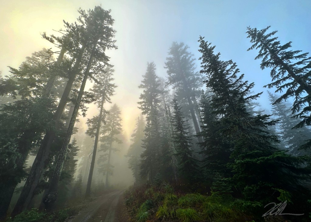
  • Of the big rivers that flow from the rainy western slopes of the Oregon Cascades, the Molalla might be the most abused by a century of heavy logging, thanks to private timber holdings that span much of the watershed. Yet, in the midst of nearly continuous clearcuts and logging spur roads a ribbon of beautiful rainforest survives along the lower river. This land is held by the Bureau of Land Management, and forms the Molalla Recreation Corridor. While spared the corporate chainsaws, this green ribbon of public land was hit hard by the Riverside Fire that swept through in September 2020. 

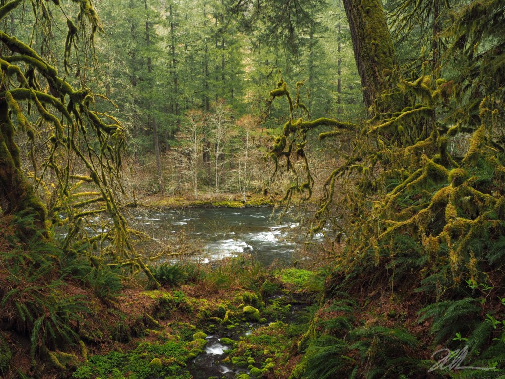
    While some trees survived the fire, though this verdant scene along the Molalla is now mostly a memory. The mossy, gnarled Bigleaf map on the left still stands, though as a bare skeleton killed by the fire. The big Douglas fir leaning in from right collapsed entirely into the river, leaving only the shards of its burned-out trunk. The forest across the river fared better, with most of the tall Douglas fir stand surviving, as did the trio of Red alder trees along the riverbank. The mossy spring in the foreground is little changed, surprisingly, as most of the ferns and understory have bounced back from the fire and are now thriving.

    ___________

    Image Description: White riffles mark a wide, rambling mountain river, framed by a gnarled, moss-covered Bigleaf maple on the left and the thick, dark trunk of a large Douglas fir on the right. Across, the river, a stand of tall, straight Douglas fir with dark trunks rise behind a trio of white-barked Alder trees.  A clear, tumbling spring pours through moss-covered rocks in the foreground.

    Photo © WyEast Images (2026)

  • Winter snow means the annual closure of Lolo Pass Road, and the beginning of a very quiet season on the rugged northwest side of Mount Hood. It’s a time of stunning beauty, when the colorful cliffs and spires familiar to summer hikers are blanketed in deep snow and ice. This image was captured in early winter, after the first big snowstorms had arrived, but before the coldest winter temperatures had set in, leaving Lolo Pass accessible with just a foot of snow to navigate.

    This perspective shows the imposing Sandy Headwall, a near-vertical 2,000-high ring of cliffs that shed constant snow avalanches to supply the Sandy Glacier. Crevasses seen in the lower part of this view mark the upper extent of the glacier. 

    Climate change is causing all of Mount Hood’s glaciers to recede, and the Sandy is among the most affected due to its comparatively low elevation. Its origin, at just 8,800 feet, is the lowest among the active glaciers on the mountain. This rapid melting led to the formation of the spectacular Sandy Glacier Caves several years ago, a much studied and documented phenomenon, though fleeting in their existence.

    ___________

    Image Description: Rugged, pyramid-shaped Mount Hood is draped in heavy snow with long evening shadows creating contrasting shades of blue and white. Dark, rocky pinnacles and ridges push through the snow on the steepest parts of the mountain. Behind the mountain, the sky is a light mist of clouds against dark blue sky. Wrinkles in the smooth, snow-covered Sandy Glacier at the base of the mountain mark crevasses in the ice.

    Photo © WyEast Images (2026)

  • When the days get shorter each winter, and the sun is low on the southern horizon, thick mountain fog can seemingly appear out of nowhere as evening approaches on cold, clear days. Though invisible to our eye, the clear winter air is usually dense with water vapor barely held in suspension by the sun’s rays. As the sun begins to fade toward sundown, so does the energy needed to sustain vapor, and droplets of water quickly condense to form fog. 

    This scene is along the historic Bennett Pass Road where it follows the high ridge dividing the East Fork Hood River and White River valleys. The image captures a moment at the end of a late November when dense fog had already engulfed the East Fork valley (on the right), where the ridge had already blocked the setting sun. Fog was quickly forming on the White River side (left), as well, lit up in this scene with the last rays from the setting sun. 

    Ridges and peaks are often left as islands above the fog, with the heavy, condensed air sinking into valleys, below. In this scene, the fog buildup had nearly crested the ridge, though clear skies remained visible overhead.

    ___________

    Image Description: Ancient Noble fir trees tower 150 feet above a narrow wagon road disappearing into flog along a forested Cascade Mountain ridgetop. The dense fog filters through the trees, partly illuminated gold and yellow with rays from the setting sun. Tufts of bright green Beargrass (an alpine member of the Lily family) grow in the foreground, their sword-shaped leaves heavy with dew.

    Photo © WyEast Images (2026)

  • Photographers from around the world come here to capture this classic Columbia River Gorge landscape during the spectacular bloom season in April and early May, when yellow Balsamroot and blue Lupine blanket the wide, windswept meadows. 

    Much of the Rowena Crest landscape was rescued from private development in the late 1970s and 1980s as the Tom McCall Preserve by the Nature Conservancy of Oregon. The non-profit  continues to own and manage the land, and generously welcomes thousands of visitors each year to explore the trails here.

    ___________________

    Image Description: late afternoon sunlight casts long shadows during the annual wildflower spectacle at Rowena Crest in the Columbia River Gorge. Ponderosa pine boughs sway in the breeze in this scene, as a lone, wind-sculpted Oregon white oak begins to leaf out after weathering another stormy winter in the Gorge. Blooms of bright yellow Balsamroot (part of the sunflower family) and deep blue spikes of Lupine (a member of the pea family) complete the vibrant spring scene.

    Photo © WyEast Images (2026)